Sunday, June 30, 2013

Emily's Bridge - Really Haunted?

Sunday drive --- just a short one.  Fairfax to Johnson, Johnson to Hydepark and Morristown, Morristown to Stowe. We made a quick stop at the visitor's center by Madonna Mobile to pick up the latest Vermont Official Road Map and Guide to Vermont Attractions.  Finally, one printed this year!

Two bridges in Johnson.  The Powerhouse Bridge is easy to find just left off 100C onto School Street.

Powerhouse Bridge, Johnson
 The Scribner Bridge is also just off 100C a short drive down Rocky Road.  This queenpost bridge is almost 48 feet long.
Scribner Bridge


A roundabout drive through Hydepark brought us to the Red Bridge. (And I don't mean we went around the pain-in-the-butt traffic circle at Route 15 and 100.) I mean we almost got lost in Hydepark and Morristown. What we should have done was head down Stagecoach Road with a right onto Sterling Valley Road.

Sterling Brook
 The Red Bridge is unique because it uses both a kingpost and queenpost.
Red Bridge, Morristown

I like the red.
 Just after I told Dan to slow down on the very twisty Sterling Valley Road we saw this sign!  Haha.


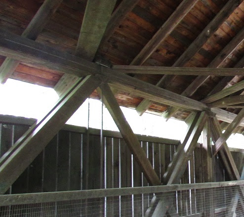
After a quick pit stop at a very clean port-a-potty near the Stowe bike path we headed up School Street to find the reportedly haunted Emily's Bridge.  Not much action at high noon on a Sunday.  Some tourists were swimming in the freezing water under the bridge, but no sign of Emily.  Emily gets blamed for hurting animals on the bridge and causing flashing light, and warm or cool spots depending on the season.  This bridge is over Gold Brook where you might just be lucky enough to find tiny gold nuggets if you don't mind the very cold water coming off the mountain.
Emily's Bridge

Emily's Bridge is a Howe bridge.
A Howe truss bridge is a bridge that uses iron rods instead of vertical timbers to make the bridge stronger.  The rods can be tightened as the bridge ages.

Stowe Walkway Bridge
 The Brookdale Bridge is located at the northern most Stowe bike path parking lot.  This covered bridge is just a youngster.  It was built in 1964. It doesn't look nearly as sturdy as most of the other bridges we have seen.
Sometimes labeled White Capp Bridge
A nice sunny day ... so far!

The Notch
A quick trip through Smuggler's Notch, beautiful as usual, and we were on our way home.  We might have stopped for a quick look around but parking on a warm, summer was at a premium.

Total number of Vermont covered bridges seen so far: 34.

Happy 4th of July everyone.  Dan has a couple of days off this week perhaps we will head south on our next adventure!

Helpful travel app


I forgot to mention yesterday as we were heading up route 242 toward Jay Peak, Dan told me about an app he had just installed on his Iphone.  An altimeter! We climbed over 2000 feet.


My current location! 
The other thing I forgot to mention was our short side-trip through New Hampshire.  We traveled through the town of Groveton and spotted another beautiful covered bridge.  We didn't take time to visit but here is a link. http://www.nh.gov/nhdhr/bridges/p61.html.  It appears they have about half as many bridges as we lucky Vermonters.

Saturday, June 29, 2013

Missed Bridge Found

Today we were on a mission to find the bridge we missed last week.  See what I meant about the signs!

Hill West

West Hill
Between Hill West and West Hill on Creamery Road we found this much abused bridge.  It has been restored and you can drive over it but it looks like a local party place.

Creamery Road

Creamery Bridge in Montgomery

It has a pretty deep ravine under it.

 Next on our list was the River Road Bridge in Troy.  This bridge is over the Missisquoi River.

River Road Bridge in Troy.


I thought it would be fun to include the Google Maps version of this bridge.


The map we were using had this bridge mislocated.  The Roy Ingalls Bridge is located just south east of Coventry on the Covered Bridge Road.
Roy Ingalls Or Orne Bridge
We were followed on this bridge by a sweet older gentleman who thought we stopped in the middle of the bridge for a kiss.  We really stopped so I could get a photo of this sign that said this bridge was rebuilt in 1999 by Blow & Cote out of Morrisville.  The gentleman was there because he is planning on building a scale model of the bridge.  He also told us it had to be rebuilt because it had been burned down by some kids.


To bad we weren't here two weeks ago at the Lord's Creek Bridge in Irasburg, we could have crashed the  wedding reception they held on this old bridge.  It does need some tender loving care!

Lord's Creek Bridge

Side trip: This is an interesting covered bridge in Island Pond.  


To the New Hampshire border next  Over and hour and a half and one Subway stop later in Orleans, we arrived at the Columbia Bridge which spans the White River between Lemington, VT and Columbia, New Hampshire.  Since most of this bridge is considered to be in New Hampshire they pay to maintain it. It was last restored in 1981. It is 145.8 feet long.


Columbia Bridge viewed from New Hampshire.

We headed south to Lunenburg were we checked out the Mount Orne Bridge.  We had to wait for another car to cross the bridge toward us.  They were bridge hunters too!  This massive bridge which also spans the White River is 266.3 feet long. It connects Lunenburg, Vermont with Lancaster, New Hampshire.

Mount Orne Bridge, Lunenburg, Vermont

As we headed west we decided to forgo a trip to Lyndonville where 5 more bridges are located.  The skies were lowering and we didn't want to press our luck with the rain.  Our final stop of the day was the Fisher Railroad Bridge in Wolcott.


I literally have driven by this bridge a hundred times and never have stopped before. The Fisher Bridge is enormous!!!  The cupola provided a way to vent the train engine smoke.  The bridge is no longer in use.  Most of the timbers on the floor of the bridge look rotten.

The Fisher Railroad Bridge

Dan doesn't look very tall compared to this bridge.

We did pretty well today. No rain when we were viewing the bridges and only two kick butt down pours to deal with.  It was raining like crazy when we came through Johnson so we will get those two bridges another day!  Enjoy the rest of your weekend and let's all pray for a few DRY days in a row! 


Sunday, June 23, 2013

Darn ... we missed one!

Sunday drive.  Headed out toward Waterville.  Overcast but not raining yet.


There were plenty of bridges to see!  There were two kinds of bridges.  The first several we saw were Queenpost bridges.  

Village/Church Bridge
Waterville
Front view of Village/Church bridge over the North Branch of the Lamoille River.

Just a couple of miles up 109 we passed the Montgomery bridge on the right. Quick back track for the photo opp!
Montgomery Bridge

This bridge is in the Queenpost truss style.
Notice the two beams on the diagonal bracing the main cross beam and posts.

About a mile from the Montgomery Bridge was Jaynes Bridge.  According to Ed Barna in his book, Covered Bridges of Vermont, the Kissing Bridge sign was attached by a visitor in the 1950's. 

The Kissing Bridge or Jaynes Bridge


Leaving Waterville we headed into the little town of Belvidere.  Just off route 109 on Back Road we found this cute little bridge. Just over 12 feet wide.

Mill Bridge in Belvidere
 A couple of miles after the Mill Bridge is the Morgan bridge. Also just over 12 feet wide.  Both of these Queenpost style bridges were built by Lewis Robinson.  (I would guess although can't prove that all of the bridges we saw earlier were also designed by Lewis Robinson or a relative of his. All the same style very close together.)
Morgan Bridge in Belvidere
 Next we found several bridges built by the Jewett Brothers. The following bridges are all lattice style.

Lattice style Hutchins Bridge

The Hutchins bridge has recently had some recent restoration.
The white paint on the Hutchins lattice bridge made it stand out.

As it turns out all of the  lattice bridges we saw today built by the Jewett brothers had white paint on the entrances.  Some of the maps show a bridge in Hectorsville.  But I read that was disassembled and stored in 2002.  

The Fuller Bridge in Montgomery.

Comstock Bridge in Montgomery


Side view of the Comstock.  I found it interesting that some of the bridges also had side openings.
This one shows off the latticework.

And now for the one we missed.  We laughed when we went by the single entrance for two roads, Hill West Road and West Hill Road.  Instead of laughing I should have been paying better attention to my map. Alas, we missed the West Hill Bridge on the Creamery Bridge road which connects West Hill with Hill West.  (Wouldn't want to drive for UPS up here!)  Road trip for another day, Cheryl!
 Just north of Montgomery on route 109 we stopped at the poor Longley Bridge.  It has issues...


Can you see why the Longley Bridge is currently closed?  Yes, we have a leaner!

Poor bridge.
 One more bridge in this area located right on the Richford, Montgomery, Enosburg line is the Hopkins Bridge.  Very pretty from a distance as well as up close.

Hopkins Bridge

Love the sign.

Hopkins Bridge in Montgomery

Maybe I missed the West Hill Bridge because I was hungry.  Since we were near Berkshire we made a quick pit stop at the following local landmark.

The Pine Cone for burgers and fries on route 105.

Saw these beauties on Grange Road in Enosburg Falls.
We had to stop at this historic landmark in Fairfield.  The birthplace of Chester A. Arthur, our 21st President.
Chester A. Arthur birthplace in Fairfield.


Are we lost?

Nope, almost to East Fairfield for our final bridge of the day.  The East Fairfield Bridge is located on Bridge Street just off of Mill Street. We ended the day crossing one more Queenspost.


This picture was on the bridge.  Been there a while.


Well that's it for today's ride. 11 bridges.  Way to go Montgomery, you have a lot of covered bridges!  We'll be back to finish our tour some day.  Can't wait to check out West Hill and Hill West!!!!